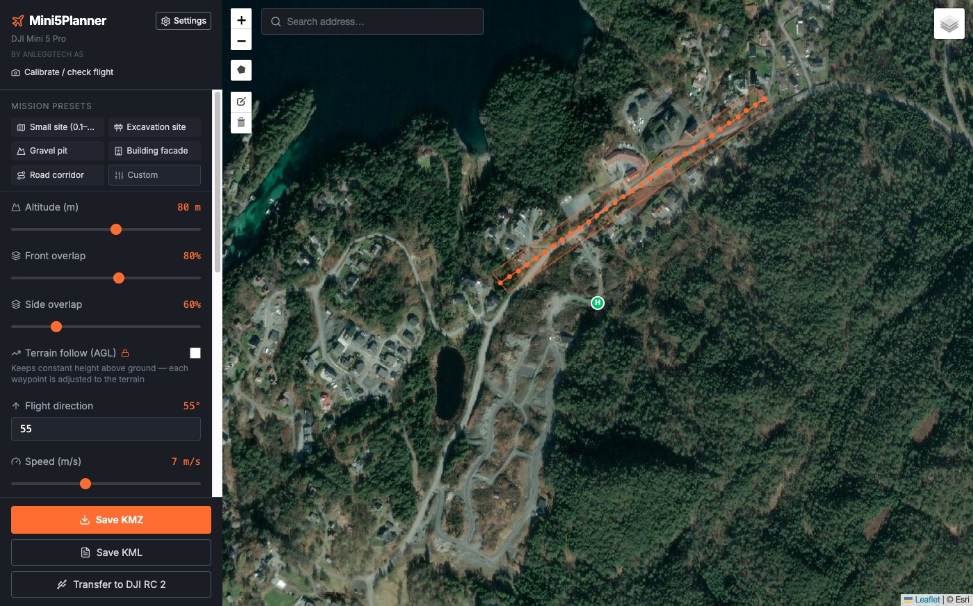
Mini5Planner is a free drone mapping planner for Mac and Windows, built around the DJI Mini 5 Pro. Draw an area on the map and pick a template, and it creates a KMZ grid mission that you load on your remote controller and fly as a waypoint mission in DJI Fly.
Free to download and use. The installers are also on GitHub.
Draw the area, pick a mission type or template, then copy the KMZ to the DJI RC 2.
How it works
Draw area → export KMZ → fly
DJI Fly has waypoints, but no grid generator and no overlap calculator, so every point has to be placed by hand. Mini5Planner builds the grid for you. It makes the flight route only: the photos are stitched into an orthophoto, point cloud or 3D model afterwards in software such as WebODM, or you can send them to us.
Grid missions for photogrammetry
The right overlap without doing the math
Mini5Planner works out line spacing and photo interval from your drone’s camera and the altitude you choose. You set front and side overlap yourself, for example 80% and 70%.
GSD and footprint update as you adjust
Single grid or double grid (crosshatch)
Gimbal straight down (−90°) or oblique (−70° or −45°), for example for facades
Mission templates
Small site, excavation, gravel pit, facade, road corridor
Five ready-made templates for typical construction and survey jobs. Pick one and adjust it if you like.
Altitude, overlap, speed and gimbal angle are set for each job type
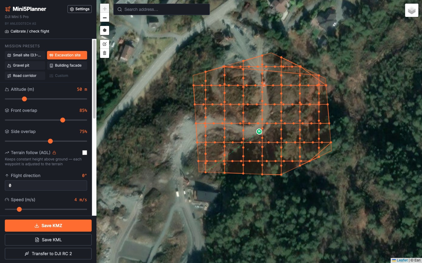
Excavation sites are flown as a double grid with an oblique gimbal
English or Norwegian interface, following your computer’s language
KMZ straight to the DJI RC 2
Built-in transfer guide
Exports WPML 1.0.2 KMZ files that DJI Fly can run. A step-by-step guide in the app shows how to copy the KMZ to the DJI RC 2 over USB-C, on Windows and on Mac.
WPML 1.0.2, the same format DJI Pilot 2 uses
7 DJI drones (Mini 5 Pro, Mini 4 Pro, Air 3/3S, Mavic 3/3 Pro/4 Pro)
Updates install automatically
Speed set by the camera, not just the map
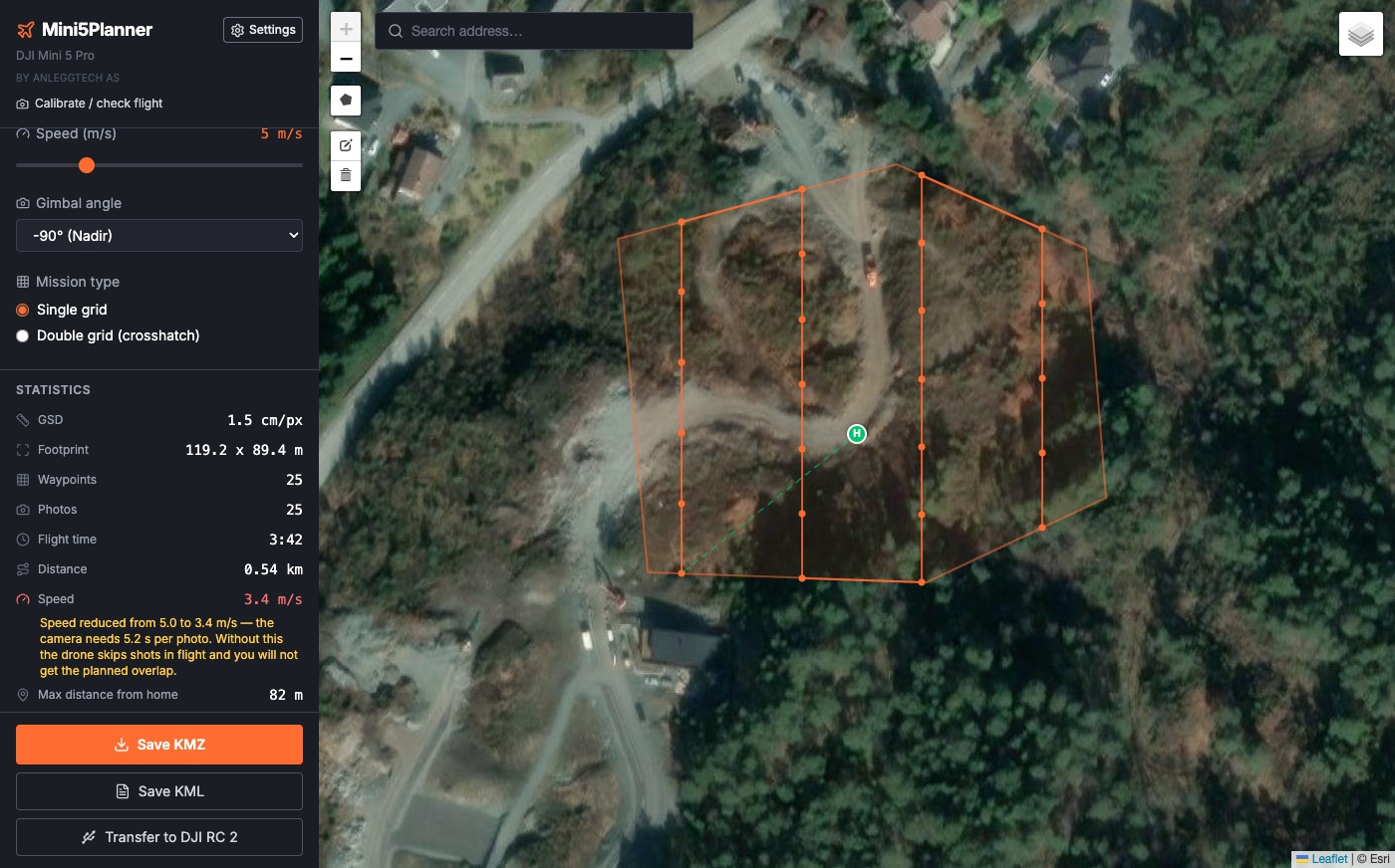
On the Mini 5 Pro, a 50 MP photo takes about 5 seconds to save. If a route asks for photos faster than that, the drone skips shots without any warning and the overlap collapses. On our first mapping flight, 154 planned photos became 89. Mini5Planner caps the mission speed so the camera keeps up, and tells you when it has lowered the speed.
Measured on the Mini 5 Pro (5.2 s per 50 MP photo). The other drone profiles use an estimated 2 s.
After the change, two flights over the same site delivered 105 of 105 photos each, with 84% measured front overlap.
Choose the photo folder after the flight. The app reads the EXIF metadata in the photos and shows how the flight actually went. Photos are not changed or sent anywhere.
Actual photo interval
Camera profile from the photos
Front overlap for every photo pair
Weak spots shown on the map
Movable takeoff point (H)
Drag the H marker to where the drone actually takes off. Battery estimates and terrain following (Pro) are calculated from that point.
A takeoff point you have moved yourself stays put
With terrain following, the point must be confirmed before export
Supported DJI drones
Seven models, all free. The app knows each drone’s camera and maximum speed and calculates GSD and footprint. Speed is set by how fast the camera saves photos. So far that has only been measured on the Mini 5 Pro; the other profiles are estimates until you calibrate them from your own photos.
DJI Mini 5 Pro
1" CMOS · C0 — 249 g
DJI Mini 4 Pro
1/1.3" CMOS · C0 — 249 g
DJI Air 3
1/1.3" CMOS · C1
DJI Air 3S
1" CMOS · C1
DJI Mavic 3
4/3" CMOS · C2
DJI Mavic 3 Pro
4/3" Hasselblad · C2
DJI Mavic 4 Pro
4/3" 100 MP · C2
Who is it for?
For anyone who wants to plan photogrammetry flights without learning heavy tools like UgCS or paying for a subscription.
Site surveys
Plan the flight over a plot. The photos can be processed into a point cloud for volume calculations.
Contractors
Document excavations, fills and material pits before, during and after the work. The drone flies the route on its own while you watch from the ground.
Drone pilots
Skip placing waypoints one by one in DJI Fly. Draw an area, adjust the overlap, export the KMZ to the DJI RC 2 and fly.
Getting started
1
Download the app
Choose Mac or Windows at the top of the page. The app is free.
2
Draw an area and export
Pick a template (Small site, Excavation site, Gravel pit, Building facade, Road corridor) or set the values yourself. Save the KMZ.
3
Transfer to the DJI RC 2
The built-in guide shows how to copy the KMZ over USB-C. Then fly the mission in DJI Fly.
4
Process the photos
Stitch them in photogrammetry software such as WebODM, or send them to us for processing. The full walkthrough is in the grid mission guide.
Screenshots
One app, five kinds of missions
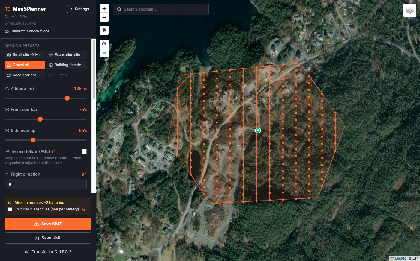
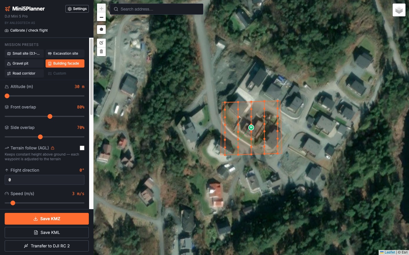
Single grid with live statistics. Speed drops automatically because the Mini 5 Pro camera needs 5.2 s per 50 MP photo.Double grid (crosshatch) with the Excavation site template: 50 m, 85/75 % overlap, oblique gimbal for 3D.Gravel pit template over a large area. The app shows the mission needs about two batteries and can split it (Pro).Building facade template: low altitude and a 45° gimbal around a house.Road corridor template: a narrow strip along a road, flown as a single line.
Mini5Planner Pro
Pro: terrain following and battery split
The free version covers most jobs. Pro is for flying hilly terrain or large areas. You pay once.
What you get with Pro
Terrain following with Kartverket’s 1 m elevation model in Norway and the Copernicus GLO-30 model (30 m) everywhere else. The drone keeps the same height above the ground, also in hilly terrain. In steep terrain, keep a good margin: 30 m data can be off by 10–30 m.
Battery split. Large missions are divided into legs that fit one battery each.
Updates in v1.x are included.
Lifetime license. No subscription.
$19 / €19 / £17 – one-time purchase, tax included
In Norway: 199 NOK. Checkout picks the currency for your country.
Payment is handled by Stripe (Link), which also takes care of VAT and sales tax.
How to activate
1
Buy Pro
Click “Buy Pro” and pay. Your license key is shown on screen afterwards and sent to you by email.
2
Open Settings
Start Mini5Planner and click Settings (the gear at the top of the side panel) → Pro license.
3
Paste the key
Copy the key (or the whole email) and click “Paste”. The app finds the key and activates Pro right away. The “Activate in Mini5Planner” button on the receipt page does the same.
Need volumes or a map afterwards?
Send us the photos from your flight and we process them in Kubatur, our own software for volume calculations. You don’t need your own server or a photogrammetry license.
Stockpile and heap volumes. PDF report with the volume measured against a base surface that follows the toe of the pile.
Orthophoto with property boundaries. GeoTIFF and JPG with boundaries from the Norwegian cadastre (Kartverket) on top. Norway only.
Point cloud (LAZ) and 3D model. For viewing, volumes and relative measurements.
Without ground control points, the volume is normally within about ±2% when you fly a double grid plus oblique passes. Property boundaries are indicative and do not replace a land survey. The point cloud is not suitable for setting out.
No. Mini5Planner plans the flight and exports the route as a KMZ file. Stitching the photos into an orthophoto, point cloud or 3D model is done afterwards in photogrammetry software such as WebODM/ODM, or by us if you send us the photos.
?
Do I need a DJI RC 2?
The transfer guide in the app is made for the DJI RC 2 and walks you through copying the KMZ over USB-C. We have not tested other remote controllers.
?
Which drones does it support?
Seven DJI drones: Mini 5 Pro, Mini 4 Pro, Air 3, Air 3S, Mavic 3, Mavic 3 Pro and Mavic 4 Pro, all in the free version. Only the Mini 5 Pro profile has been measured in the field. The others use published camera specs and an estimated photo interval, and you can calibrate them from your own photos with Calibrate / check flight.
?
Is it really free?
Yes. The app is free to download and use, also commercially, and all seven drones are included. Terrain following and battery split require Pro, which is a one-time purchase.
?
Mac or Windows?
Both. The buttons at the top of the page download the right file for Mac or Windows. The Mac version is a universal app for Apple silicon and Intel and needs macOS 11 or later.
?
Does it work outside Norway?
Yes. The map (OpenStreetMap and satellite) and route planning work anywhere, and terrain following uses the global Copernicus GLO-30 elevation model (30 m) outside Norway. Address search and the power line layer only cover Norway, so elsewhere you find your site by moving the map.
?
Does the app send my data anywhere?
No. Your plans and photos stay on your computer. The app downloads maps, addresses, elevation data and power lines, and checks for updates. The license key is checked locally.
?
Who makes it?
AnleggTech AS in Bjørnafjorden, Norway. We build software for the construction industry, fly drones ourselves and process the photos in our own software, Kubatur.
Mini5Planner is an independent product by AnleggTech AS. It is not affiliated with, endorsed by or sponsored by DJI. DJI, DJI Fly, DJI Mini and Mavic are trademarks of SZ DJI Technology Co., Ltd.